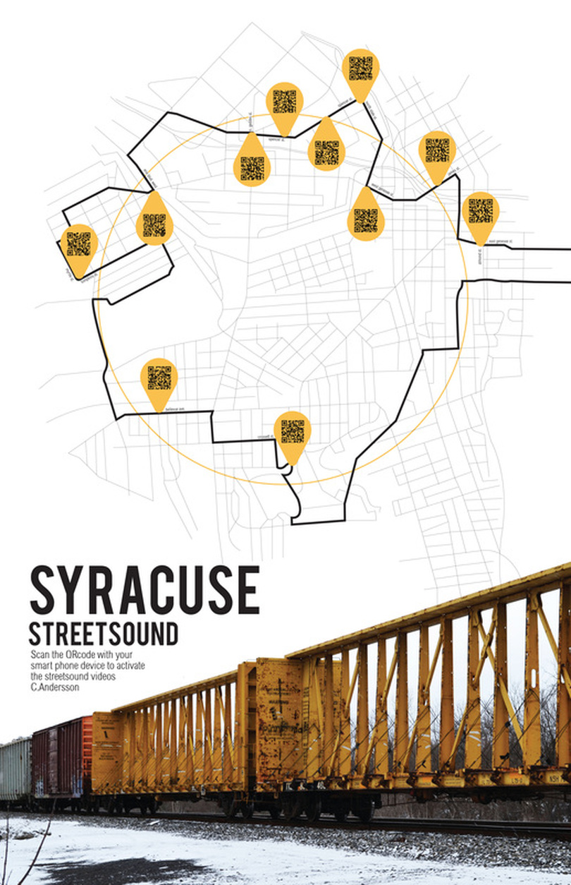
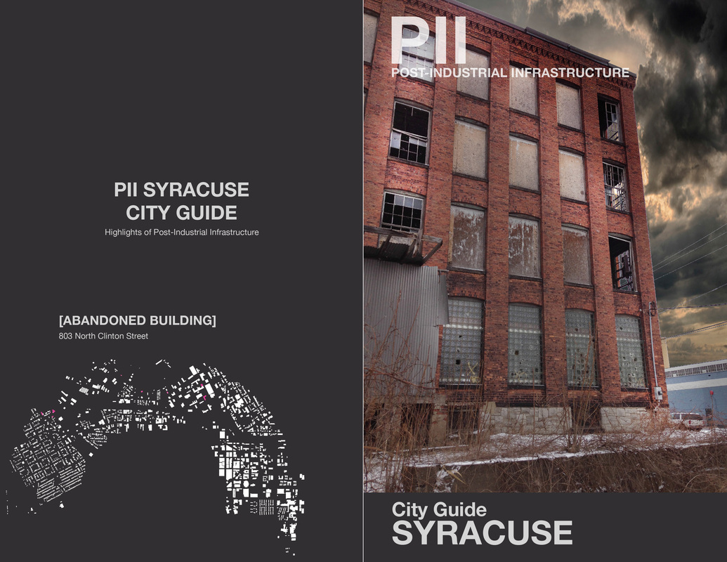
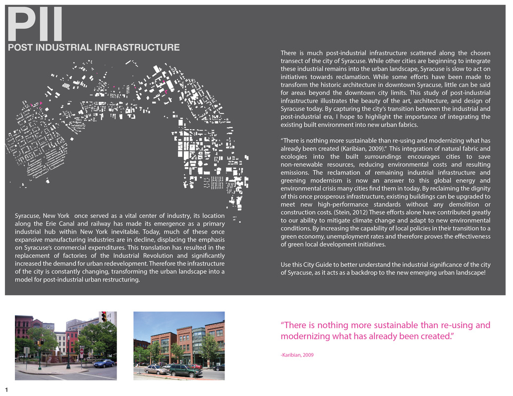
FIELD OF EXTRAORDINARY OBJECTS
“The geographer Yi-Fu Tuan defines place as "a center of meaning constructed by experience." The experiences that create a sense of place are "mostly fleeting and undramatic, repeated day after day and over the span of years. It is a unique blend of sights, sounds, and smells, a unique harmony of natural and artificial rhythms such as times of sunrise and sunset, or work and play. The feel of place is registered in one's bones and muscles."
Source: http://www.hevanet.com/windfall/wf21/wf21_afterword.pdf
Definition of REGENERATION
1: revival
2: renewal or restoration of a system after injury or as a normal process
3: utilization by special devices of other products that would ordinarily be lost
source: merriamwebster.com
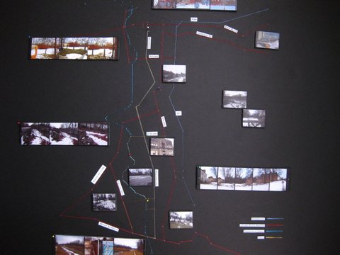
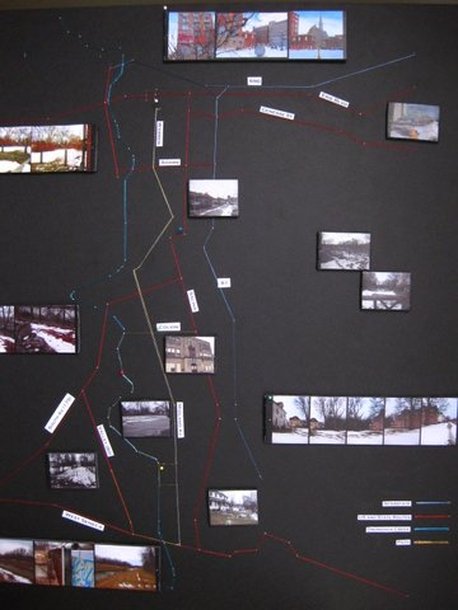
Our Syracuse, where we live, play, study and work is in need of a regeneration map. One that portrays a positive and alternative view of our shared experience of the city to contrast the defeatism that plagues cities in decay and disrepair. It is this type of city that holds the most hope for a rebirth of the most positive type in an age where ideas like sustainability, resilience and empowerment are being discussed and embraced by people from a diversity fields and backgrounds.
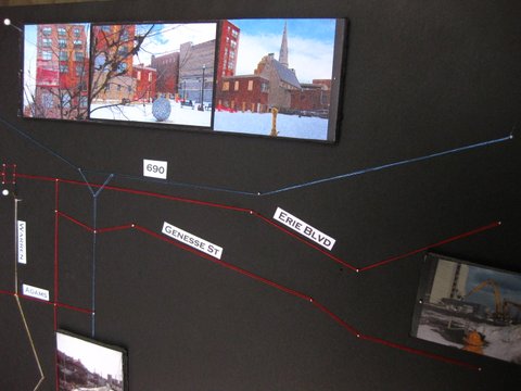
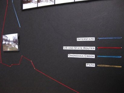
Maps are powerful tools that can reflect their authors' opinions and biases. In this particular instance we employ these perceptual artifacts to highlight extraordinary objects in a concerted effort to offer those who follow them a new perspective, portrait and understanding of the City of Syracuse. Authors Yi-Fu Tuan and Dolores Hayden and the case study of the City of Bradford, UK (blog page image source) were the inspiration for the experiments' framework and development.
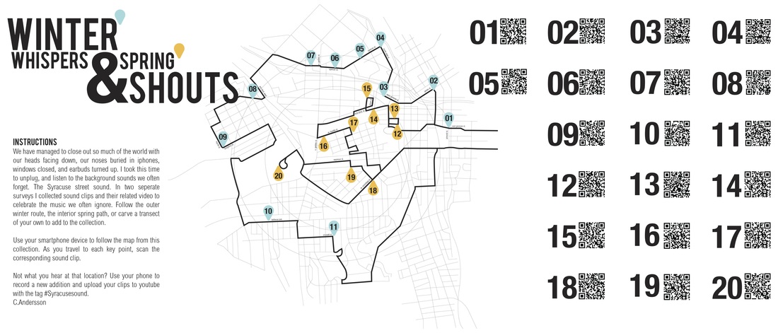
Multiple lenses, in this case 22 students, allow the focused viewing of the realities of the City of Syracuse, NY to be portrayed alternatively. The study boundary they defined dictated a 22 mile circular transect and a three block radii deviation rule. The inspiration for this method came from Richard Long's circle walks, where he literally walked circles in the landscape, deviating only for landscape barriers. Similarly, each student diverged from the original transect onto their own unique path to follow sounds, smells, the suggestions of strangers, the path of least resistance, the river, or other interesting phenomena.
Below are their discoveries...
Doors
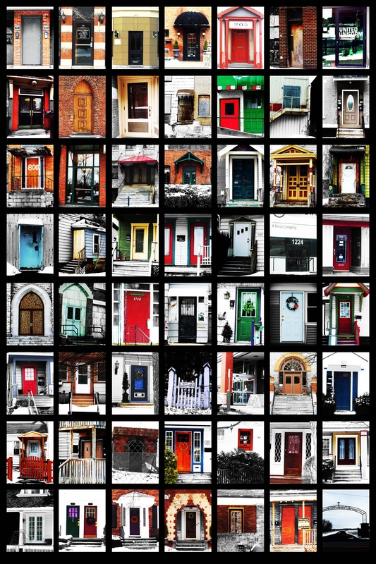
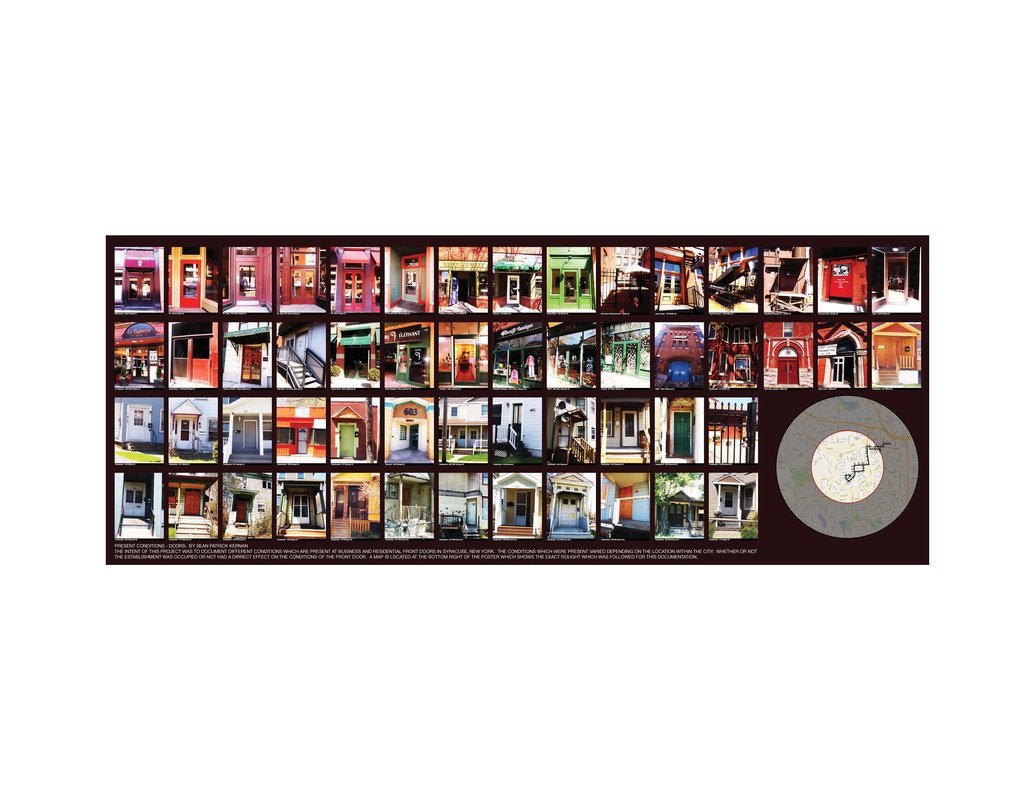
In each and every city in America, there is a distinct feel and character which goes a long with the city. This feeling is created and influenced by many different factors. Income, seems to be one of the main contributing factors to the appearance of the space. For this study, the appearance of doors a long a transect was looked at and documented. Throughout my travels, it became very apparent, very quickly what the general income of the house hold which was photographed would be placed into. Lower income housing often times has no glass present on or around the door, and general the style and uniqueness of the door is much more generic; there is nothing to set the door apart from another house. A separate style of door which was documented were retail doors. These were generally much more complex and were constructed generally with larger glass pains, or with a more ornate appearance. My study has taught me that doors can be a work of art within the landscape and help to define the character of the
surrounding space. They are also defined by the opportunities and incomes of the ones who reside within their protection.
Sean Patrick Kernan
surrounding space. They are also defined by the opportunities and incomes of the ones who reside within their protection.
Sean Patrick Kernan
Sean Patrick Kernan: Part 2
| final_presentation.pdf | |
| File Size: | 2813 kb |
| File Type: | |
lighting up cuse
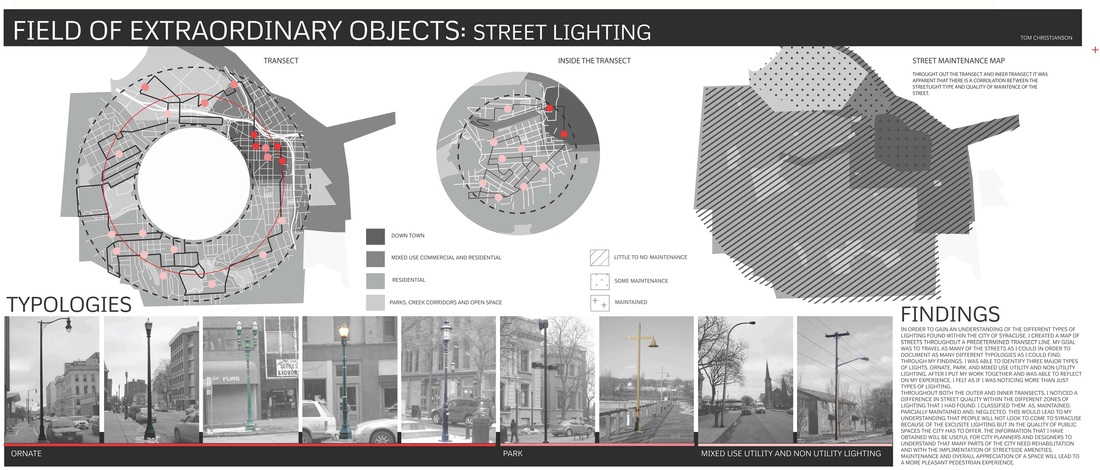
IN ORDER TO GAIN AN UNDERSTANDING OF THE DIFFERENT TYPES OF LIGHTING FOUND WITHIN THE CITY OF SYRACUSE, I CREATED A MAP OF STREETS THROUGHOUT A PREDETERMINED TRANSECT LINE. MY GOAL WAS TO TRAVEL AS MANY OF THE STREETS AS I COULD IN ORDER TO DOCUMENT AS MANY DIFFERENT TYPOLOGIES AS I COULD FIND. THROUGH MY FINDINGS, I WAS ABLE TO IDENTIFY THREE MAJOR TYPES OF LIGHTS. ORNATE, PARK, AND MIXED USE UTILITY AND NON UTILITY LIGHTING. AFTER I PUT MY WORK TOGETHER AND WAS ABLE TO REFLECT ON MY EXPERIENCE, I FELT AS IF I WAS NOTICING MORE THAN JUST TYPES OF LIGHTING.
THROUGHOUT BOTH THE OUTER AND INNER TRANSECTS, I NOTICED A DIFFERENCE IN STREET QUALITY WITHIN THE DIFFERENT ZONES OF LIGHTING THAT I HAD FOUND. I CLASSIFIED THEM AS, MAINTAINED, PARTIALLY MAINTAINED AND, NEGLECTED. THIS WOULD LEAD TO MY UNDERSTANDING THAT PEOPLE WILL NOT LOOK TO COME TO SYRACUSE BECAUSE OF THE EXQUISITE LIGHTING BUT IN THE QUALITY OF PUBLIC SPACES THE CITY HAS TO OFFER. THE INFORMATION THAT I HAVE OBTAINED WILL BE USEFUL FOR CITY PLANNERS AND DESIGNERS TO UNDERSTAND THAT MANY PARTS OF THE CITY NEED REHABILITATION AND WITH THE IMPLEMENTATION OF STREET SIDE AMENITIES, MAINTENANCE AND OVERALL APPRECIATION OF A SPACE WILL LEAD TO A MORE PLEASANT PEDESTRIAN EXPERIENCE.
Tom Christianson
FIELD OF EXTRAORDINARY OBJECTS : TEXTILE IDENTITY
JOSHUA THAYER
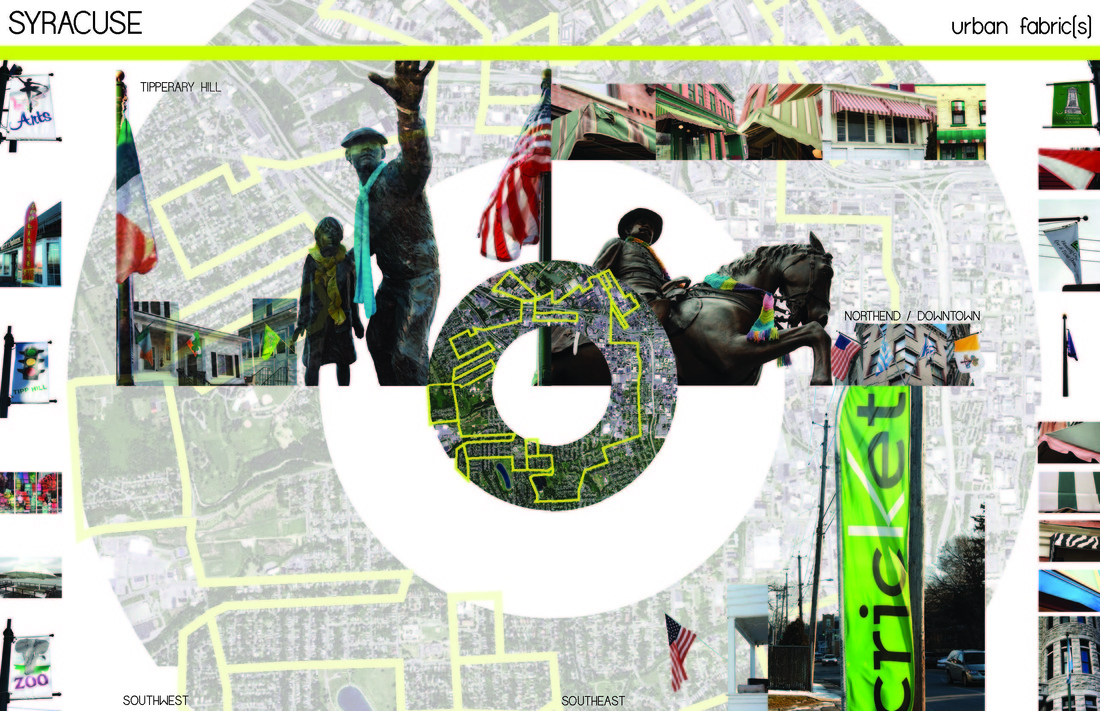
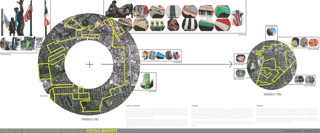
Syracuse spends nearly half of the year in a hibrination of sorts. When we were asked to explore the city in search of extraordinary objects, I chose to head out in search of fabrics. I was literally looking for textiles in the landscape. I wasn't sure what I would find, if anything at all, but I viewed fabrics in this landscape as something that could soften and brighten the grayness that engulfs Syracuse for a large portion of the year.
I discovered zones of identity during my adventures, and in some cases, a lack-there-of. What I mean by this is that some areas within our transect tend to display a common theme through textiles. In the North-End, fabric awnings were abundant and this speaks to the theme of "Little Italy" that the area is known as. In Tipperary Hill, Irish community pride is noticable by the numerous flags displayed on homes and businesses. I went in search of extraordinary textiles in the landscape and realized that there are parts of the city that have a collective identity and there are parts that don't readily display any sense of community. This project, and these maps, can be useful for us as designers of place to identify areas to focus our efforts.
I discovered zones of identity during my adventures, and in some cases, a lack-there-of. What I mean by this is that some areas within our transect tend to display a common theme through textiles. In the North-End, fabric awnings were abundant and this speaks to the theme of "Little Italy" that the area is known as. In Tipperary Hill, Irish community pride is noticable by the numerous flags displayed on homes and businesses. I went in search of extraordinary textiles in the landscape and realized that there are parts of the city that have a collective identity and there are parts that don't readily display any sense of community. This project, and these maps, can be useful for us as designers of place to identify areas to focus our efforts.
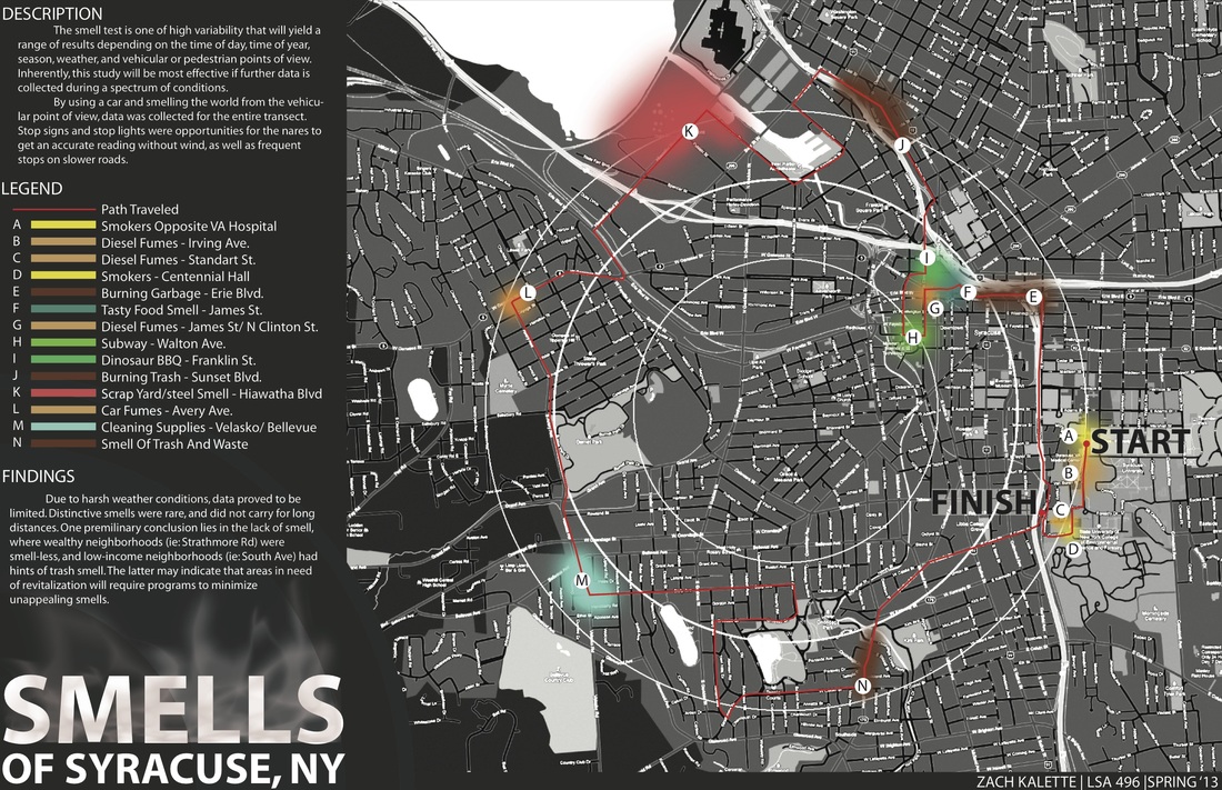
smells of syracuse
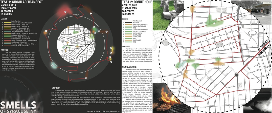
Zach Kalette
Smells of syracuse: part 2
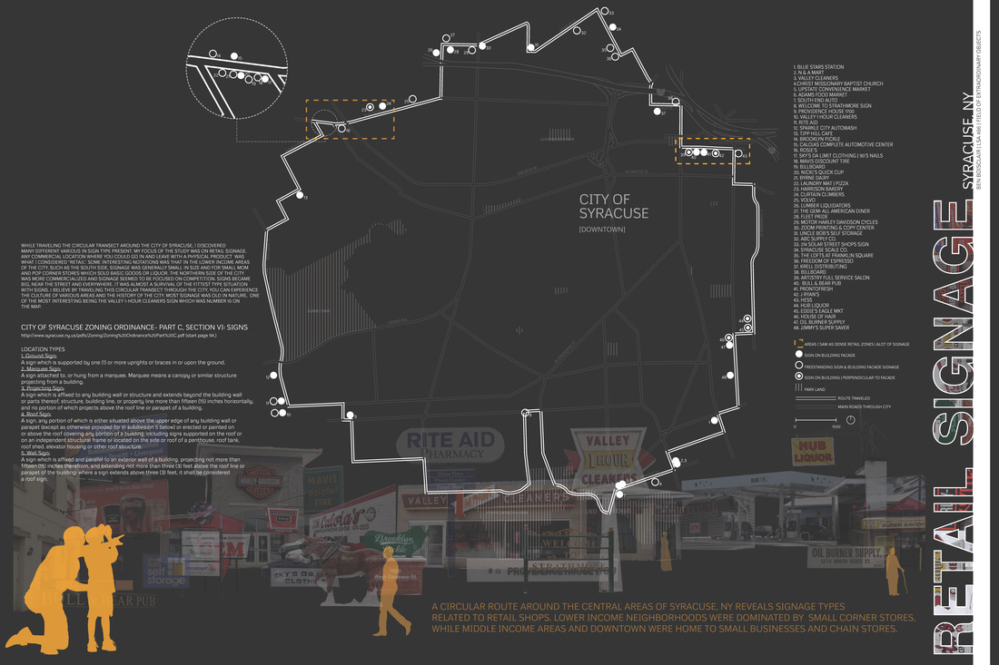
RETAIL SIGNAGE
| map_finalboard.pdf | |
| File Size: | 5718 kb |
| File Type: | |
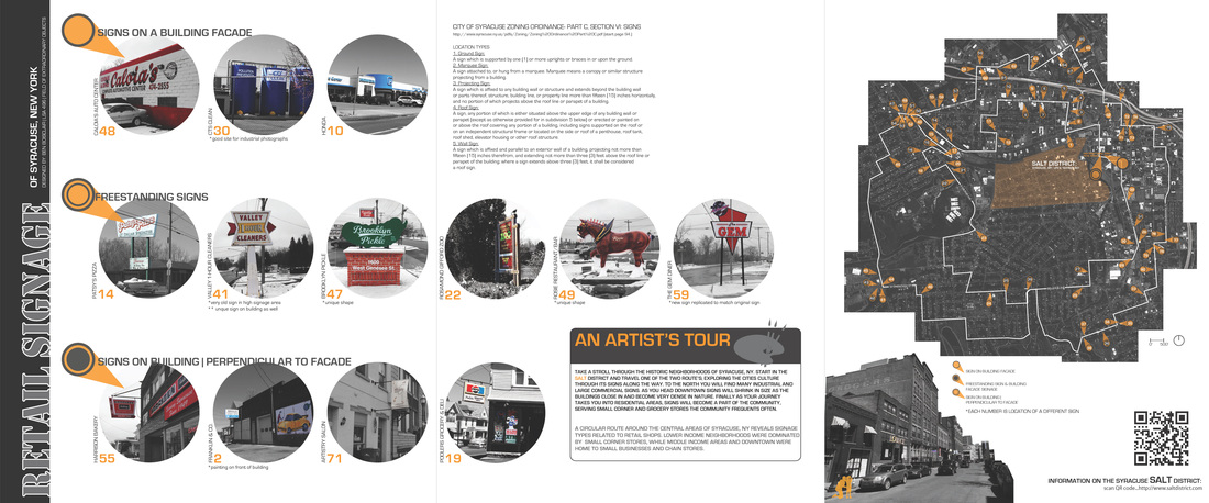
WHILE TRAVELING THE CIRCULAR TRANSECT AROUNG THE CITY OF SYRACUSE, I DISCOVERED MANY DIFFERENT VARIOUS SIGN TYPES PRESENT. MY FOCUS ON THIS INITIAL STUDY WAS ON RETAIL SIGNAGE. ANY COMMERCIAL LOCATION WHERE YOU COULD GO IN AND LEAVE WITH A PHYSICAL PRODUCT WAS WHAT I CONSIDERED 'RETAIL'. SOME INTERESTING NOTATIONS WERE THAT IN THE LOWER INCOME AREAS OF THE CITY, SUCH AS THE SOUTH SIDE, SIGNAGE WAS GENERALLY SMALL IN SIZE AND FOR SMALL MOM AND POP CORNER STORES WHICH SOLD BASIC GOODS OR LIQUOR. THE NORTHERN SIDE OF THE CITY WAS MORE COMMERCIALIZED AND SIGNAGE SEEMED TO BE FOCUSED ON COMPETITION. SIGNS BECAME BIG NEAR THE STREET AND EVERYWHERE THEY EXISTED. IT WAS ALMOST A SURVIVAL OF THE FITTEST TYPE SITUATION WITH SIGNS. I BELIEVE BY TRAVELING THE CIRCULAR TRANSECT THROUGH THE CITY, YOU CAN EXPERIENCE THE CULTURE OF VARIOUS AREAS AND THE HISTORY OF THE CITY. MOST SIGNAGE WAS OLD IN NATURE, ONE OF THE MOST INTERESTING BEING THE VALLEY 1-HOUR CLEANERS SIGN WHICH WAS NUMBER 10 ON THE MAP.
Ben Bosclair
Ben Bosclair
corner stores
Ari Muca
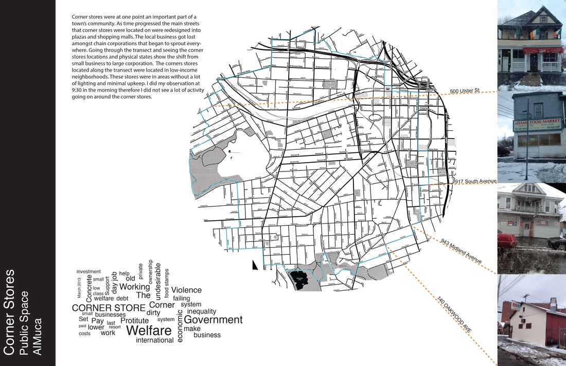
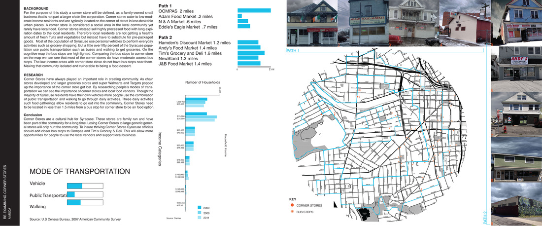
Corner Stores have historically played a large role in creating a sense of community. Following the transect lines I found that the corner stores in Syracuse are a cultural hub. These stores are family run and have been part of the community for a long time. Losing corner stores to large generic chain connivence stores will only hurt the community. By evaluating the Syracuse corner stores we can see areas that would benefit from a corner store and where public transportation needs to be increased.
| corner_store_presentation.pdf | |
| File Size: | 42754 kb |
| File Type: | |
scenes from syracuse
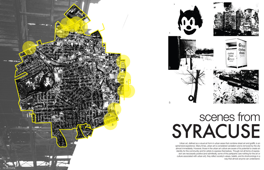
Urban art, defined as a visual art form in urban areas that combine street art and graffiti, is an ephemeral experience. Many times, urban art is considered vandalism and is removed by the city almost immediately. However, those in the urban art culture are aware of its potential to create an identity for the community and for artists to express themselves. Though not all forms of expression are neccesarily positive (and admittedly, some of the partipants care nothing for the art or culture associated with urban art), they reflect society’s values, beliefs, and its shortcomings in a way that almost anyone can understand.
Jin Huang
Jin Huang
SCENES FROM SYRACUSE PART II
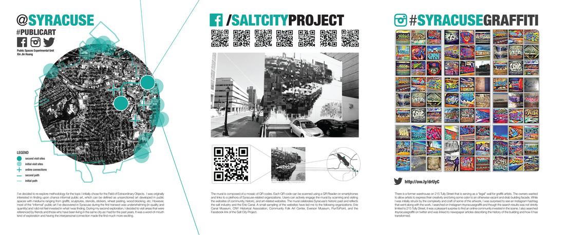
I’ve decided to re-explore methodology for the topic I initially chose for the Field of Extraordinary Objects. I was originally interested in finding upon chance informal public art. However, most of the “informal” public art I’ve discovered in Syracuse during the first transect was underwhelming (in quality and quantity( and I did not feel invested in what I was finding. During my second exploration, I decided to visit areas that were referenced by friends and those who have been living in the same city as I had for the past years. It was a word-of-mouth kind of exploration and having the interpersonal connection made the find much more exciting.
The first site is a former warehouse on 215 Tully Street that is serving as a “legal” wall for graffiti artists and was referred to me by Dan Arseneau. The owners wanted to allow artists to express their creativity and bring some color to an otherwise vacant and drab building facade. While I was initially struck by the complexity and craft of some of the artwork, I was surprised to see an Instagram hashtag that went along with the work. I searched on Instagram #syracusegraffiti and though the search results was not strictly limited to 215 Tully Street, it was a pleasant surprise to find an online community invested in the scene. I also searched #syracusegraffiti on twitter and was linked to newspaper articles describing the history of the building and how it has transformed.
The second site is a mural on S. Warren St.The mural is composed of a mosaic of QR codes. Each QR code can be scanned using a QR Reader on smartphones and links to a plethora of Syracuse-related organizations. Users can actively engage the mural by scanning and visiting the websites of community, historic, and art-related websites. The mural celebrates Syracuse’s historic past and reflects the salt industry and the Erie Canal. A small sampling of the websites have led me to the following organizations: Erie Canal Museum, CNY Historical Association, Community Folk Art Center, Everson Museum, PunToPoint, and the Facebook link of the Salt City Project.
Jin Huang
| huang_foeo_2.pdf | |
| File Size: | 24786 kb |
| File Type: | |
syracuse architecture ring part one
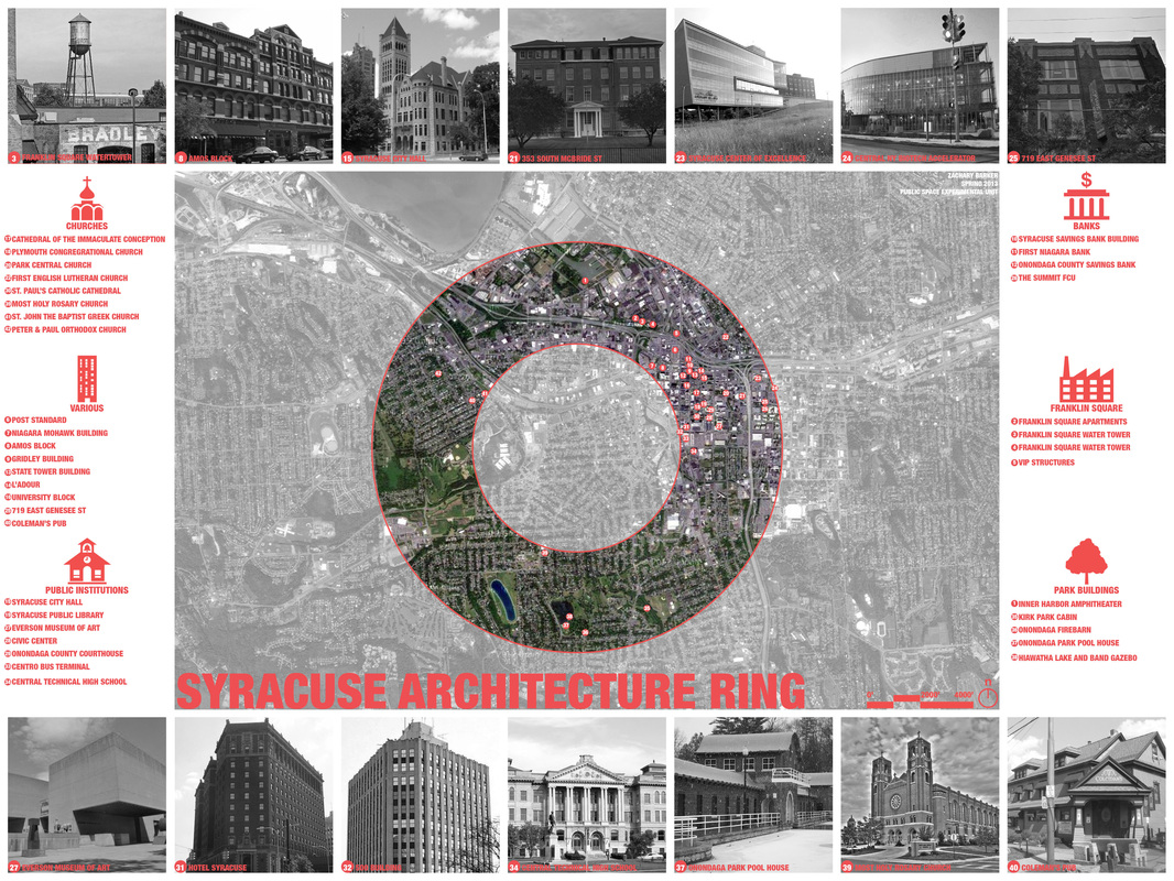
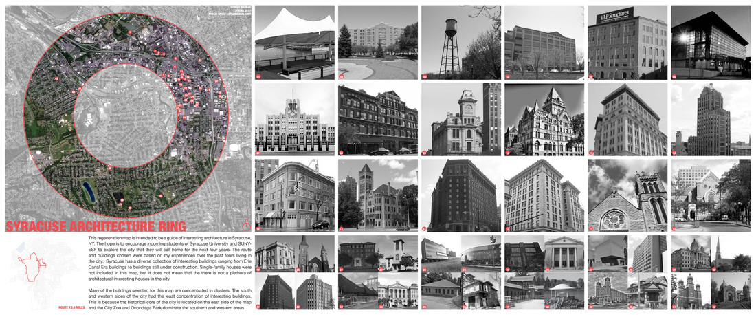
This regeneration map is intended to be a guide of interesting architecture in Syracuse, NY. The hope is to encourage incoming students of Syracuse University and SUNY-ESF to explore the city that they will call home for the next four years. The route and buildings chosen were based on my experiences over the past fours living in the city. Syracuse has a diverse collection of interesting buildings ranging from Erie Canal Era buildings to buildings still under construction. Single-family houses were not included in this map, but it does not mean that the there is not a plethora of architectural interesting houses in the city.
Many of the buildings selected for this map are concentrated in clusters. The south and western sides of the city had the least concentration of interesting buildings. This is because the historical core of the city is located on the east side of the map and the City Zoo and Onondaga Park dominate the southern and western areas.
Phase one and two of this map were essentially inventory collection. The next phase of the Syracuse Architecture ring would to be create a bicycle friendly map or wayfinding system that would allow people to find Syracuse's extraordinary architecture on there own.
Syracuse architecture ring part two
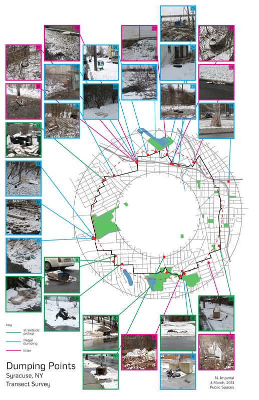
Field of (Extra)ordinary garbage - Nick Imperial
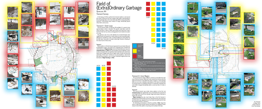
In the Spring of 2013, I performed 2 transect studies in and around the center of Syracuse, NY. Each sought to gain better understanding of the part garbage plays in the urban landscape. While moving along these transects, I documented every instance of large, intentionally placed refuse that I came across.
Transect I - Outer Loop
The first transect, taken on February 28 and March 2, covered a loop approximately 2 miles in diameter. The specific route taken could not stray more than .5 miles on either side of that circle. Every time I saw a trash item that met my criteria, I photographed it and marked its location on a map.
The generous size of my route allowed me to travel through many neighborhoods and experience a wide variety of urban landscape types. Although, for expediency’s sake, I sacrificed walking for driving after the first few miles, I was able to compile a fairly high resolution sampling of the refuse found in these areas.
Transect II - Inner Region
The second transect, taken on May 6, covered a circuit within the outer loop of the first transect. While this route covered less territory than the larger first transect, it elucidated the drastic changes in urban typology that can occur over a relatively small distance. From dense commercial, to housing project, to sprawling industrial, to mid-density residential, the urban fabric changed dramatically within a circle less than 1.5 miles in diameter.
Results
In both transects, 3 major refuse types emerged:
- Streetside Pickup: items left at the curb to be picked up by municipal sanitation services
- Litter: large collections of small inconsequential trash items (cups, cans, paper, etc.)
- Illegal Dumping: large items which have been placed illegally and intentionally (tires, furniture, boxes, bags of trash)
Transect I
Refuse patterns in the first transect appeared to be primarily influenced by geographic location. The further from residential zones I traveled, the more instances of illegal dumping I observed. Residential areas saw more streetside pickup, and litter was more prevalent close to highways. These results correspond with my hypothesis that residential zones would have lower levels of illegal refuse due to higher levels of pride and personal ownership of their users. Contrary to my preconceptions, I also found that, with few exceptions, even run-down residential neighborhoods saw low levels of illegal dumping and litter.
Transect II
The second transect saw similar refuse patterns to the first, but streetside pickup was significantly more concentrated and composed of much larger items due to the city-wide “large trash pickup” that was to happen the next day.
Illegal dumping was also much lower than in the first transect. I attribute this to the fact that much less industrial territory was traversed, and that which was, appeared to be more active and well cared for than the industrial territory in Transect I.
An interesting inconsistancy is that the quanitity of litter stayed the same, in spite of the shorter transect and absence of a highway. Further study of urban litter patterns may bring some lucidity to the topic.
| imperial_feo2_sm.jpg | |
| File Size: | 3502 kb |
| File Type: | jpg |
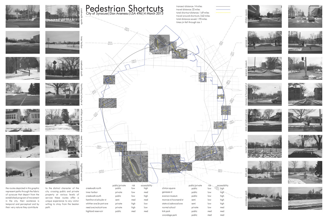
Pedestrian shortcuts
Part 1 & 2 Dan Arseneau
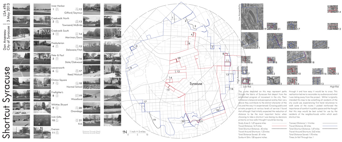
Download the interactive PDF below to view side-by-side videos of selected shortcuts and their long ways around. Click on the camera icons next to the shortcuts for a link to the videos.
| shortcuts_interactive_v2.pdf | |
| File Size: | 3652 kb |
| File Type: | |
The routes depicted on this map represent paths through the fabric of Syracuse that depart from the established program of movement in the city. Their existence is temporal and perceptual and by their very nature they contribute to the distinct character of the city and the way it is experienced. Crossing public and private property at various levels of service I found that although I had initially expected the reduction of distance to be the most important factor when choosing to take a shortcut I was basing my decisions primarily on how safe I thought I would be moving through it and how easy it would be to cross. This realization led me to reconsider my audience and what I was taking away from the project. While I originally intended this map to be something all residents of the city could use, experiencing first hand reluctance to walk some of the routes I picked reinforced the importance of comfort in pulblic space and the thought that this map would be best suited for use by the residents of the neighborhoods within which each shortcut lies.
The routes depicted in this graphic represent paths through the fabric of Syracuse that depart from the established program of movement in the city. Their existence is temporal and perceptual and by their very nature they contribute to the distinct character of the city. Crossing public and private property at various levels of service these routes offer a unique experience to any visitor willing to stray from the beaten path.
Part 1
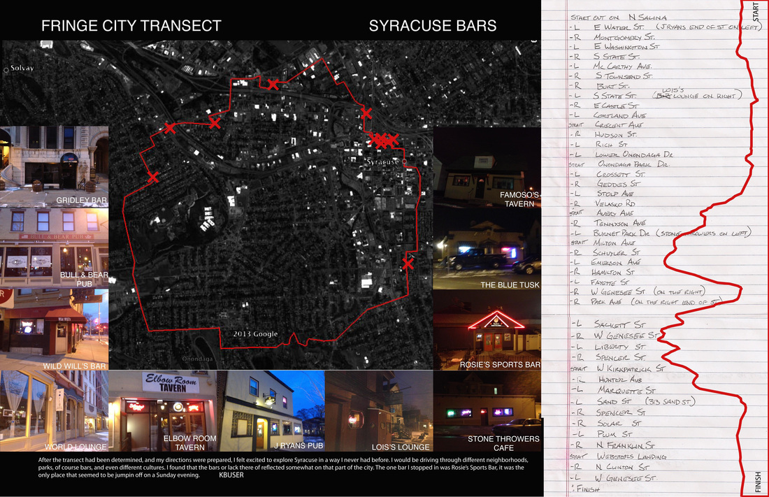
After the transect had been determined, and my directions were prepared, I felt excited to explore Syracuse in a way I never had before. i would be driving through different neighborhoods, parks, of course bars, and even different cultures. I found that the location of the bars or lack there of reflected on somewhat on that part of the city. The one bar I stopped in was Rosies Sports Bar, it was the only place that seemed to be jumping off on a cold sunday evening. - Kyle Buser
Benches of syracuse - part 1
By Kristy Pedersen
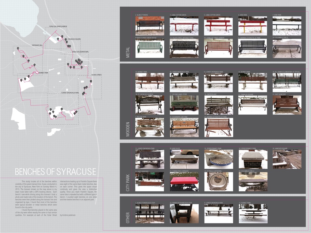
This study locates all of the benches within visibility of the given transect line. It was conducted in the city of Syracuse, New York on Sunday March 4, 2013. The transect shown on the map above is my exact route taken with a GPS tracking device. Each bench I saw while driving along this transect I took a photo and made note of the location of the bench. The benches were then plotted along the transect line and organized by type. I found that most of the benches were typical wooden or metal benches which were found in the city parks.
I found that benches placed in the same area of the city were either exactly the same or had similar qualities. For example at each of the Solar Street intersections leading up to Franklin Square there was eight of the same black metal benches, two on each corner. This gives the space visual continuity and gives the area a distinctive quality. Once you reach Franklin Square, the same idea is repeated but with a different type of bench. I counted eight benches on one street and then twelve benches in an adjacent park.
a view from the bench - part 2
By Kristy Pedersen
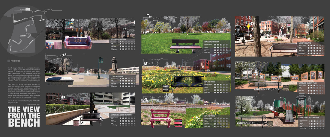
A well designed bench in a well placed location can be a great source of human activity. The main purpose of a bench is to provide users with a comfortable place to rest. However, thiings like shape, temperature, location, material, and quality can deter people from using it. Benches placed in the wrong locations can cause vandalism and become a place for homeless people to hang out.
Each bench shown on the map is graded on a scale of one to ten within five different categories: physical comfort, view, activity, safety level, and look as well as being given an overall grade. The most pleasurable benches to sit at were the ones in the downtown area where there was a lot of human activy. Many people were observed eating lunch in the parks or simply passing through.
This study was performed on May 1st at 11:30AM in Syracuse, NY.
View from the benchPrezi
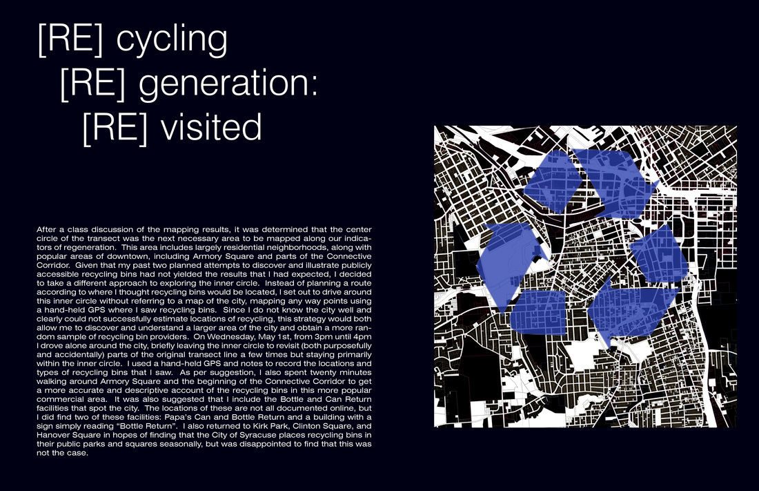
[Re] generation of Syracuse: public access [re] cycling bins
by Mackenzie Piggott
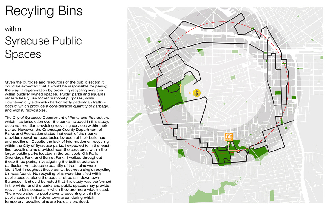
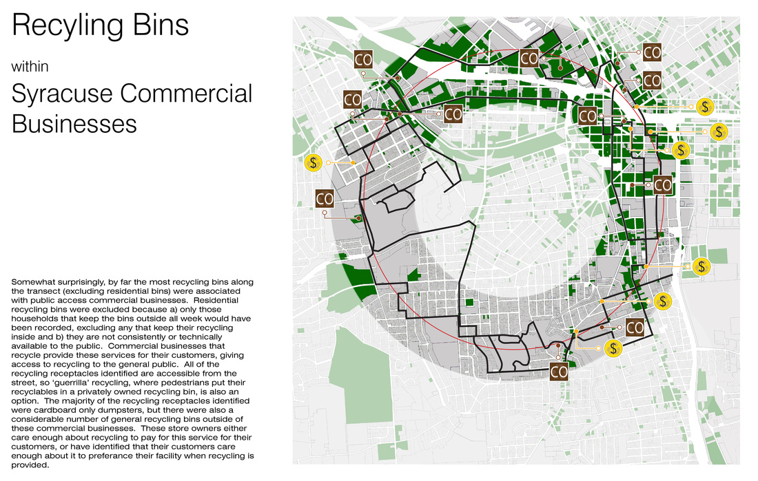
Recycling is a key component of the increasingly popular environmental movement. For cities such as Syracuse, whose economic growth and vitality peaked over a century ago, signs of regeneration can be sparse within the outdated infrastructure. So instead, I chose to look at publicly accessible recycling bins as a sign of regeneration within Syracuse - a sign that they are modernizing to make their city fit into the contemporary culture.
Recycling is a key component of the increasingly popular environmental movement. For cities such as Syracuse, whose economic growth and vitality peaked over a century ago, signs of regeneration can be sparse within the outdated infrastructure. So instead, I chose to look at publicly accessible recycling bins as a sign of regeneration within Syracuse - a sign that they are modernizing to make their city fit into the contemporary culture.
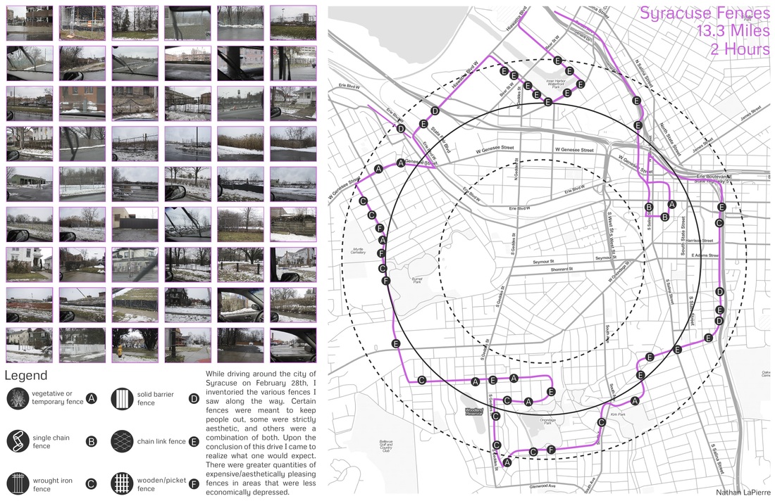
While driving through the city of Syracuse on February 28th, I inventoried the various fences I saw along the way. Certain fences were meant to keep people out, some were strictly aesthetic, and others were a combination of both. Upon the conclusion of this drive I came to realize what one would expect. There were greater quantities of expensive/aesthetically pleasing fences in areas that were less economically depressed.
| bennett_public_spaces.pdf | |
| File Size: | 32912 kb |
| File Type: | |
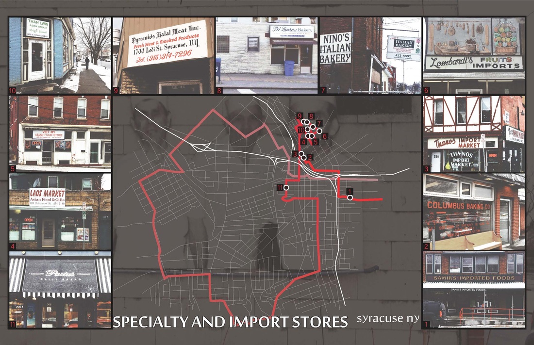
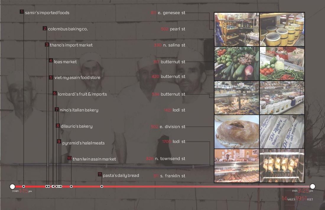
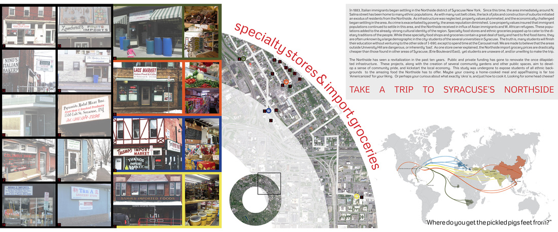
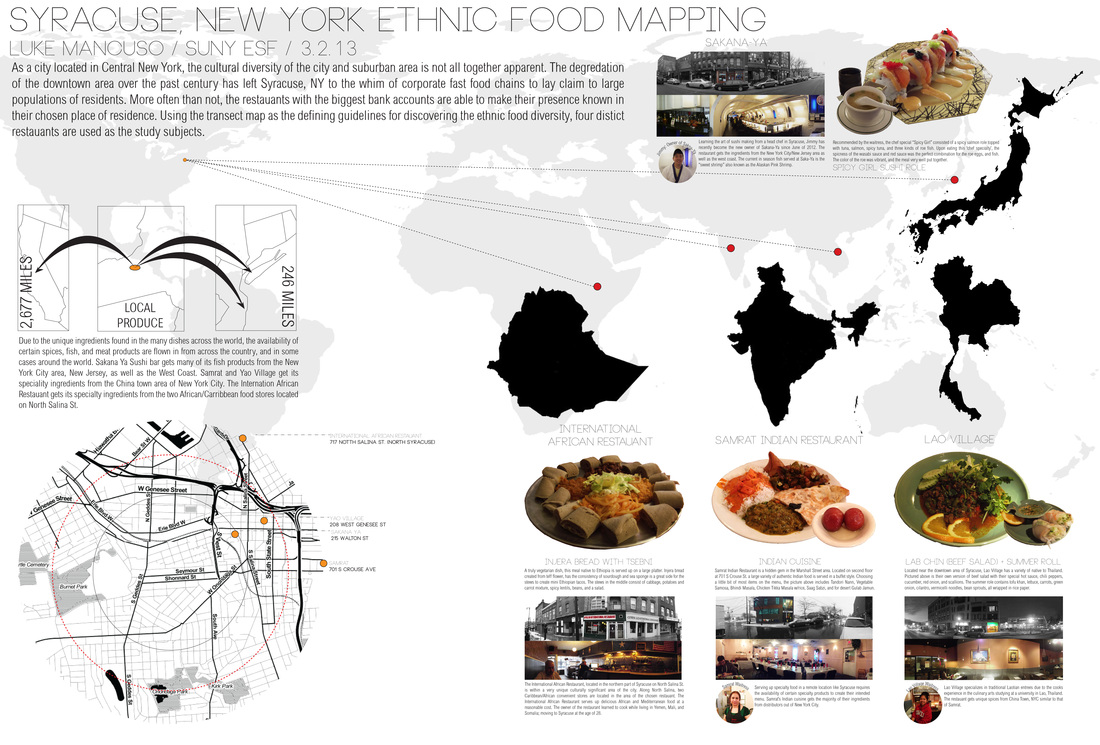
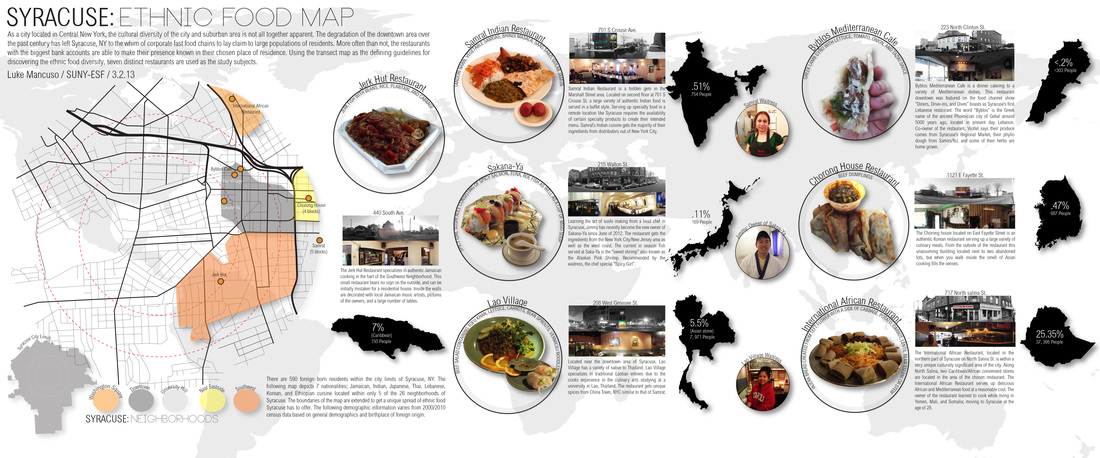
The college diet does not have to be limited to Jimmy John's subs or a Chipotle burrito bowl. Replacing your franchise meal for these local alternative benefits the local economy, the local community, and in many cases, your stomach. This map identifies Syracuse local specialty-shops and import markets. Fresh and exotic ingredients found at these locally owned establishments are bound to spruce up your next meal.
Syracuse Off-Grid
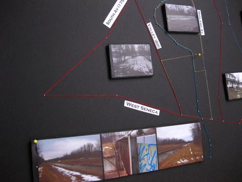
Syracuse is a city that you need to walk around in order to know its charm. To know the real Syracuse talk to a local, they will tell you what lies beyond the grid. Our journey begins with a conversation. A Syracuse native, Jasmine who lives in the South Side, points out the duck pond located near Seneca Turnpike. With careful planning, I ventured out into the depths of the South Side. I am fascinated with the Onondaga Creek, I decided to follow its path. In my walk I encountered several green areas lying near the creek. The creek is separated by the road and a fence which lay side by side. After this exploration I see a little more of the real Syracuse.
By Ana Maria Castillo Ruiz
By Ana Maria Castillo Ruiz
| bennett_final_ps.pdf | |
| File Size: | 39580 kb |
| File Type: | |
RETAIL SIGNAGE: AN ARTIST'S TOUR
BY: BEN BOISCLAIR TAKE A STROLL THROUGH THE HISTORIC NEIGHBORHOODS OF SYRACUSE, NY. START IN THE SALT DISTRICT AND TRAVEL ONE OF THE TWO ROUTE'S; EXPLORING THE CITIES CULTURE THROUGH ITS SIGNS ALONG THE WAY. TO THE NORTH YOU WILL FIND MANY INDUSTRIAL AND LARGE COMMERCIAL SIGNS. AS YOU NEAR DOWNTOWN SIGNS WILL SHRINK IN SIZE AS THE BUILDINGS CLOSE IN AND BECOME VERY DENSE IN NATURE. FINALLY AS YOUR JOURNEY TAKES YOU INTO RESIDENTIAL AREAS, SIGNS WILL BECOME A PART OF THE COMMUNITY, SERVING SMALL CORNER AND GROCERY STORES THAT COMMUNITY MEMBERS FREQUENT OFTEN. |
| ||||||
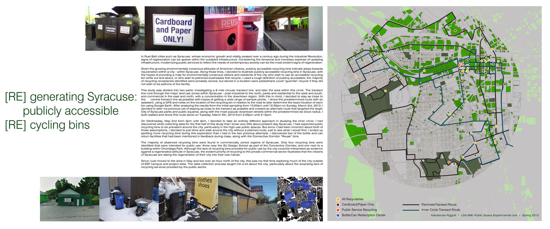
[re] generating Syracuse: publicly accessible [re]cycling bins
by Mackenzie Piggott
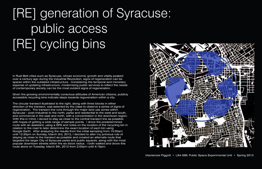
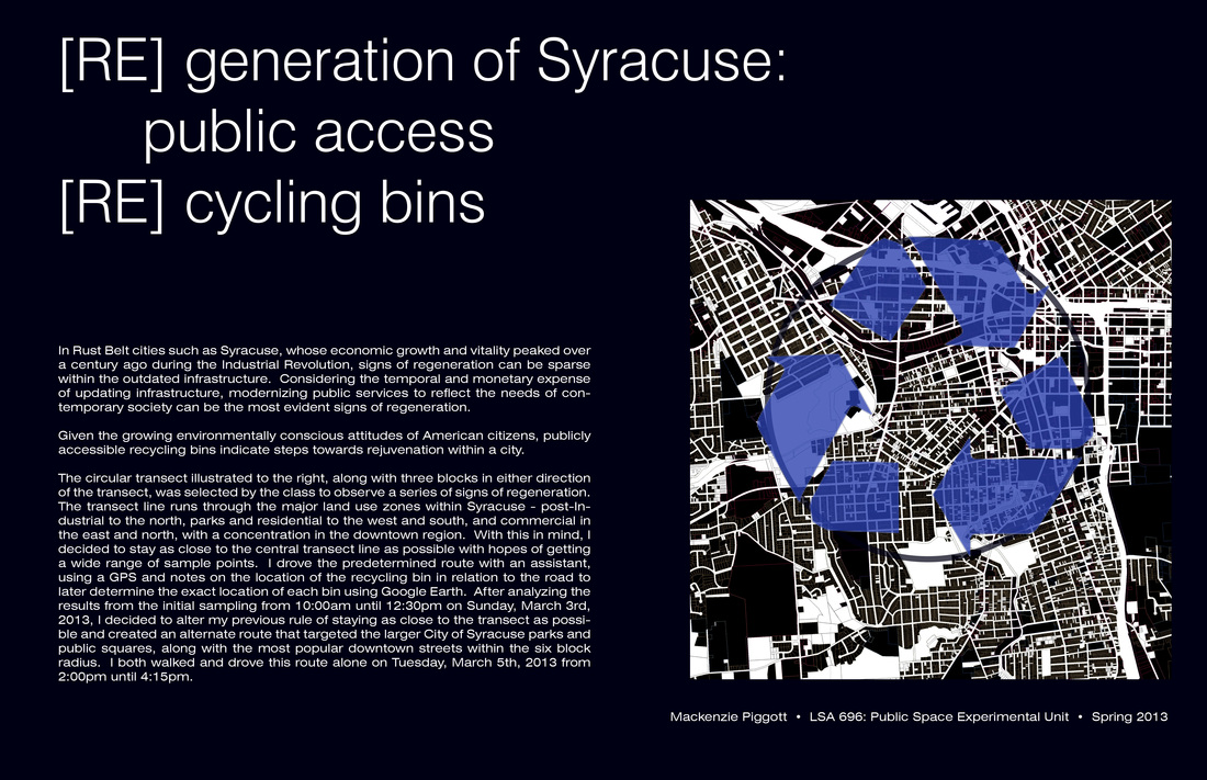
In Rust Belt cities such as Syracuse, whose economic growth and vitality peaked over a century ago during the Industrial Revolution, signs of regeneration can be sparse within the outdated infrastructure. Considering the temporal and monetary expense of updating infrastructure, modernizing public services to reflect the needs of contemporary society can be the most evident signs of regeneration.
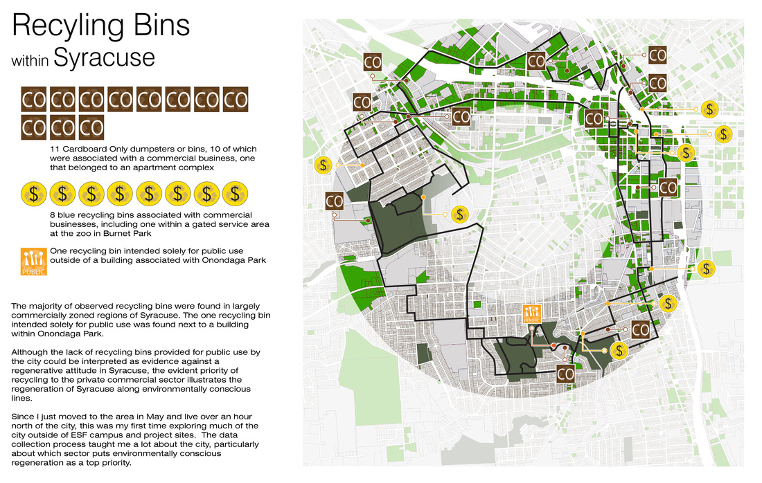
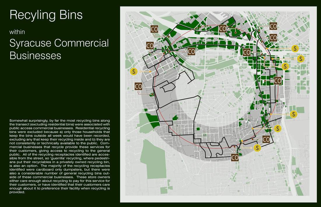
Given the growing environmentally conscious attitudes of American citizens, publicly accessible recycling bins indicate steps towards rejuvenation within a city - within Syracuse. Along these lines, I decided to illustrate publicly accessible recycling bins in Syracuse, with the hopes of providing a map for environmentally conscious visitors and residents of the city who wish to use an accessible recycling bin while out and about, or who wish to patronize businesses that recycle. I used a rough definition of publicly accessible; the majority of recycling receptacles identified were privately owned, but stored in a location were pedestrians could "guerrilla" recycle if they did not wish to be patrons of the facility.
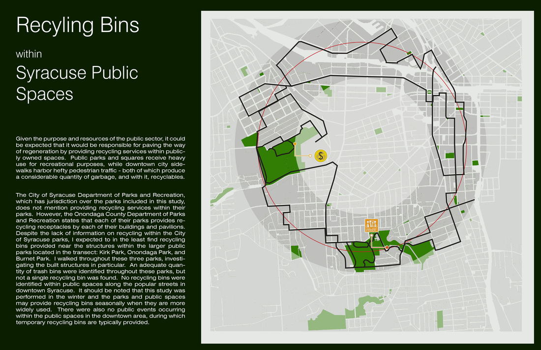
This study was divided into two parts: investigating a 9 mile circular transect line, and later the area within this circle. The transect line runs through the major land use zones within Syracuse - post-Industrial to the north, parks and residential to the west and south, and commercial in the east and north, with a concentration in the downtown region. With this in mind, I decided to stay as close to the central transect line as possible with hopes of getting a wide range of sample points. I drove the predetermined route with an assistant, using a GPS and notes on the location of the recycling bin in relation to the road to later determine the exact location of each bin using Google Earth. After analyzing the results from the initial sampling from 10:00am until 12:30pm on Sunday, March 3rd, 2013, I decided to alter my previous rule of staying as close to the transect as possible and created an alternate route that targeted the larger City of Syracuse parks and public squares, along with the most popular downtown streets within the predetermined six block radius. I both walked and drove this route alone on Tuesday, March 5th, 2013 from 2:00pm until 4:15pm.
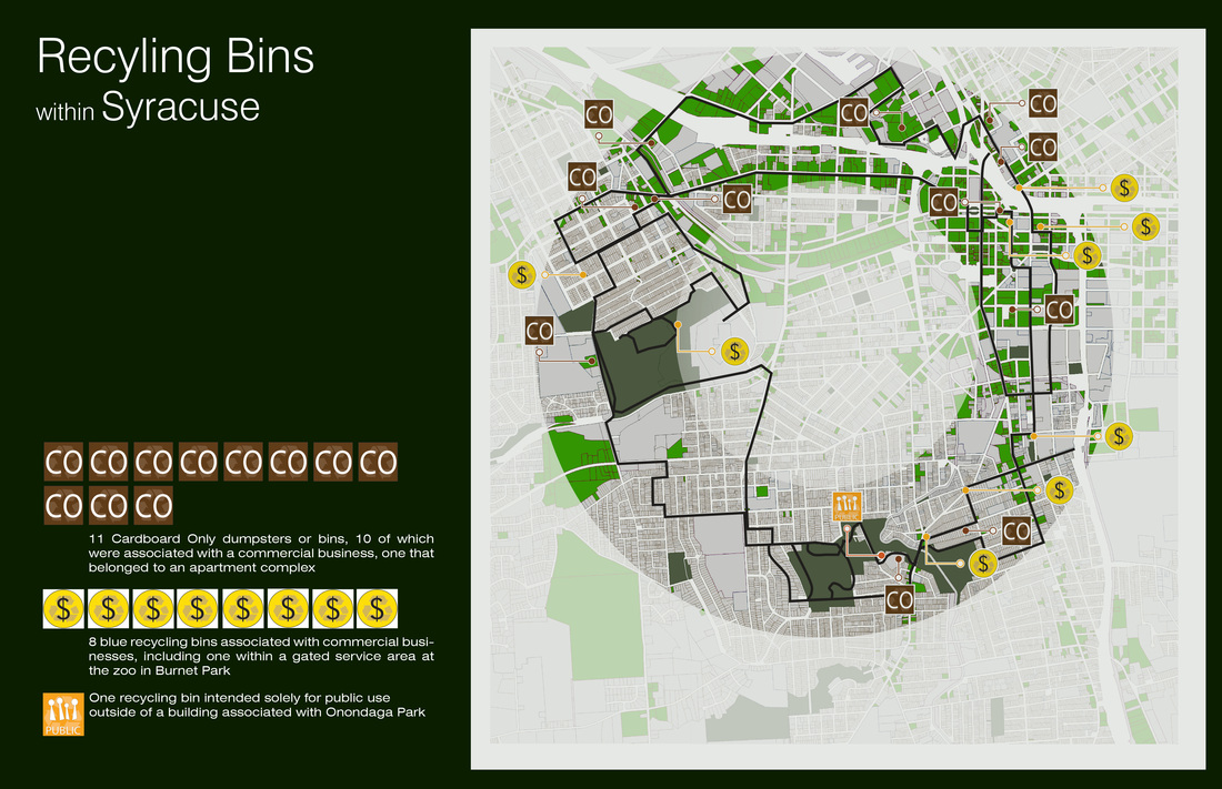
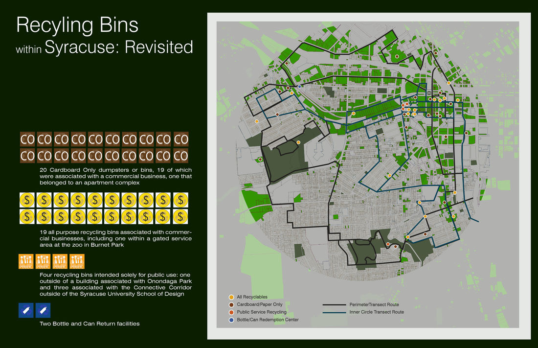
On Wednesday, May 2nd from 3pm until 4pm, I decided to take an entirely different approach in studying the inner circle. I had discovered while collecting data for the first half of this study that I know very little about present-day Syracuse. I had expected public recycling bins to be prevalent around the city, particularly in the high-use public spaces. But since I had been incorrect about both of those assumptions, I decided to just drive and walk around the city without a planned route, just to see what I would find. I ended up spotting more recycling bins during this exploration than I had in the two previous attempts. I discovered two of the
bottle and can return facilities that had been mentioned in feedback during class, along with the Connective Corridor "Reuse" bins.
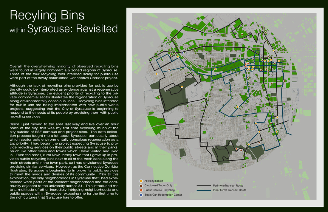
The majority of observed recycling bins were found in commercially zoned regions of Syracuse. Only four recycling bins were identified that were intended for public use: three near the SU Design School as part of the Connective Corridor, and one next to a building within Onondaga Park. Although the lack of recycling bins provided for public use by the city could be interpreted as evidence against a regenerative attitude in Syracuse, the evident priority of recycling to the private commercial sector illustrates that the citizens of Syracuse are taking the regeneration of their city into their own hands.
Since I just moved to the area in May and live over an hour north of the city, this was my first time exploring much of the city outside of ESF campus and project sites. The data collection process taught me a lot about the city, particularly about the surprising lack of recycling services provided by the public sector.
Below is the presentation for the recycling map of Syracuse.
fences
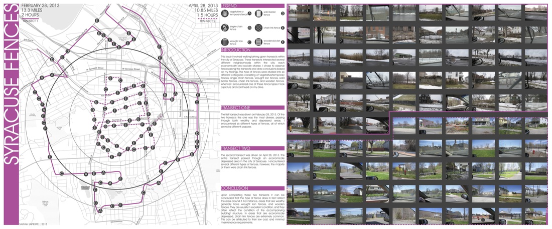
This study involved walking/driving given transects within the city of Syracuse. These transects intersected several different neighborhoods within the city, each economically and socially diverse. I chose to observe fences along the transects and draw conclusions based on my findings. The type of fences were divided into six different categories consisting of vegetative/temporary fences, single chain fences, wrought iron fences, solid barrier fences, chain link fences, and wooden fences. Whenever I encountered one of these fence types I took a picture and continued on my drive.
The first transect was driven on February 28, 2013. Of the two transects this one was the most diverse, passing through both wealthy and depressed areas. I encountered six different types of fences, all of which served a different purpose.
The second transect was driven on April 28, 2013. This entire transect passed through an economically depressed area in the city of Syracuse. I encountered several different types of fences, however, the majority of them were chain link fences.
Upon completing these two transects it can be concluded that the type of fence does in fact reflect the area around it. For instance, areas that are wealthy generally have wrought iron fences, and wooden fences. They are usually in excellent condition, and they often reflect the condition of the accompanying building/ structure. In areas that are economically depressed, chain link fences are extremely common. This can be attributed to their low cost, and minimal maintenance requirements.
FENCES
sounds
specialty stores & import groceries
|
|
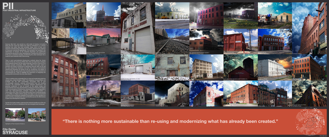
In 1883, Italian immigrants began settling in the Northside district of Syracuse New York. Since this time, the area immediately around N. Salina street has been home to many ethnic populations especially Asian immigrants and W. African refugees. Specialty food stores and ethnic groceries popped up to cater to the dietary traditions of the people. While these specialty food shops and groceries contain a great deal of tasty and hard to find food items, they are often unknown by a large demographic in the city: students of the several universities in Syracuse.
This study was undergone to expose students of all ethnic backgrounds to the amazing food the Northside has to offer. Maybe your craving a home-cooked meal and appeThaizing is far too ‘Americanized’ for your liking. Or perhaps your curious about what exactly ‘okra’ is, and just how to cook it. Looking for some head cheese? TAKE A TRIP TO SYRACUSE’S NORTHSIDE |
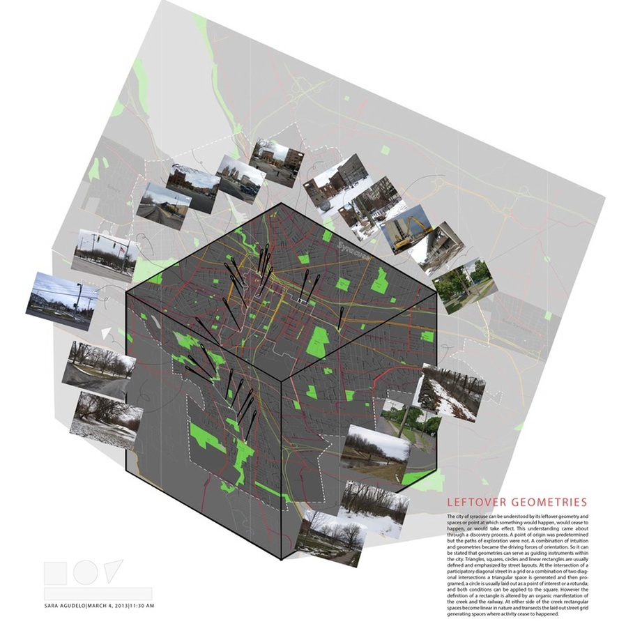
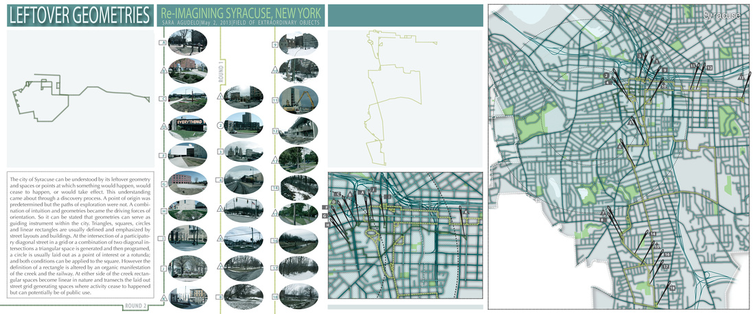
leftover geometries
barriers and public houses
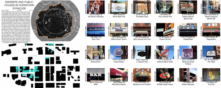
After completing the first transect, which can be seen on the base map, there was a lot of things I would do differently the second time around. The fact of the matter is that most of the bars in Syracuse are clustered around the epicenter of its revitalization in downtown. Of course there are other bars scattered throughout the city, such as Dinosaur BBQ, and Shiftys, but these are either destinations on their own or local drinking holes and dive bars. I chose to focus my inventory on the bars in the downtown area, where people come to work and then to drink and meet with friends and co-workers during a happy hour. It’s where young people come once the sun goes down to have some fun. There are a wide variety of establishments you can choose from based on the type of atmosphere you are looking for. My target audience would be the evening happy hour crowd because of the range in age groups at the bars. This second time around I took more care with my photo selection using shots of the bars logos and signs. These are used to draw in customers and in many cases you can tell everything you need to know about the place from its logo. -Kyle Buser
ethnic food mapping
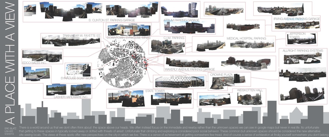
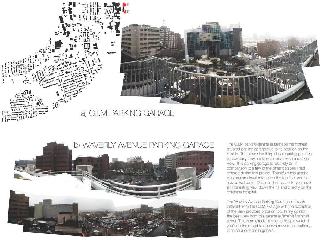
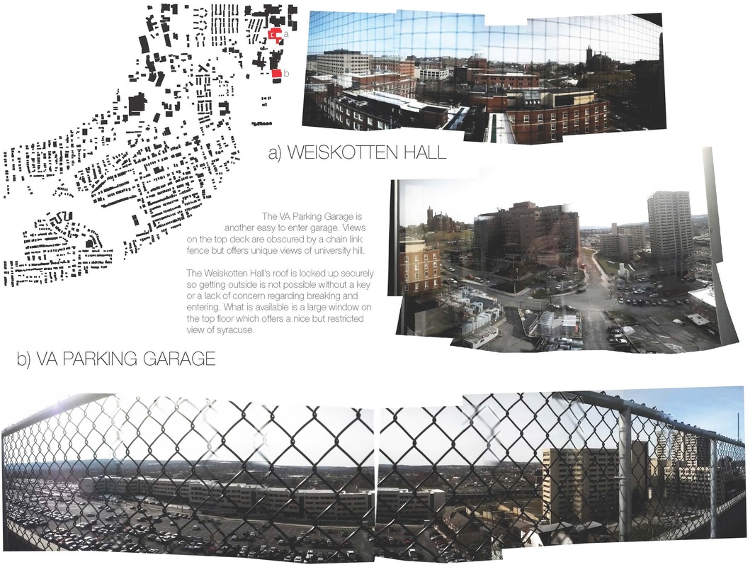
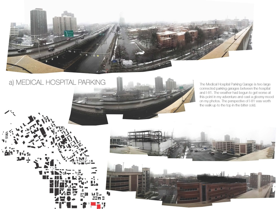
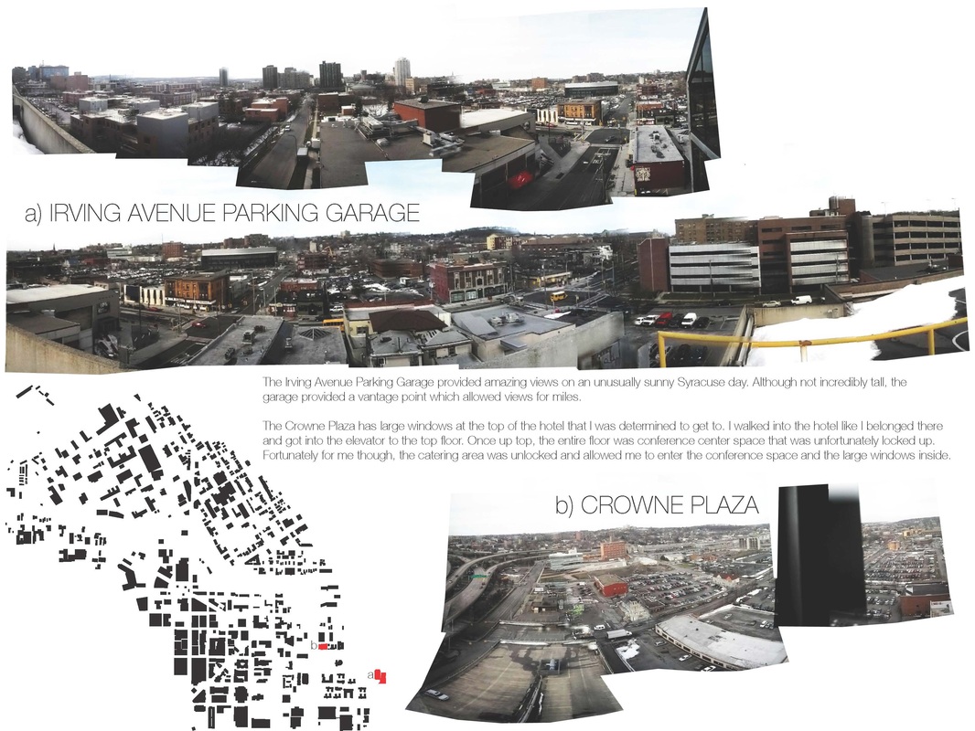
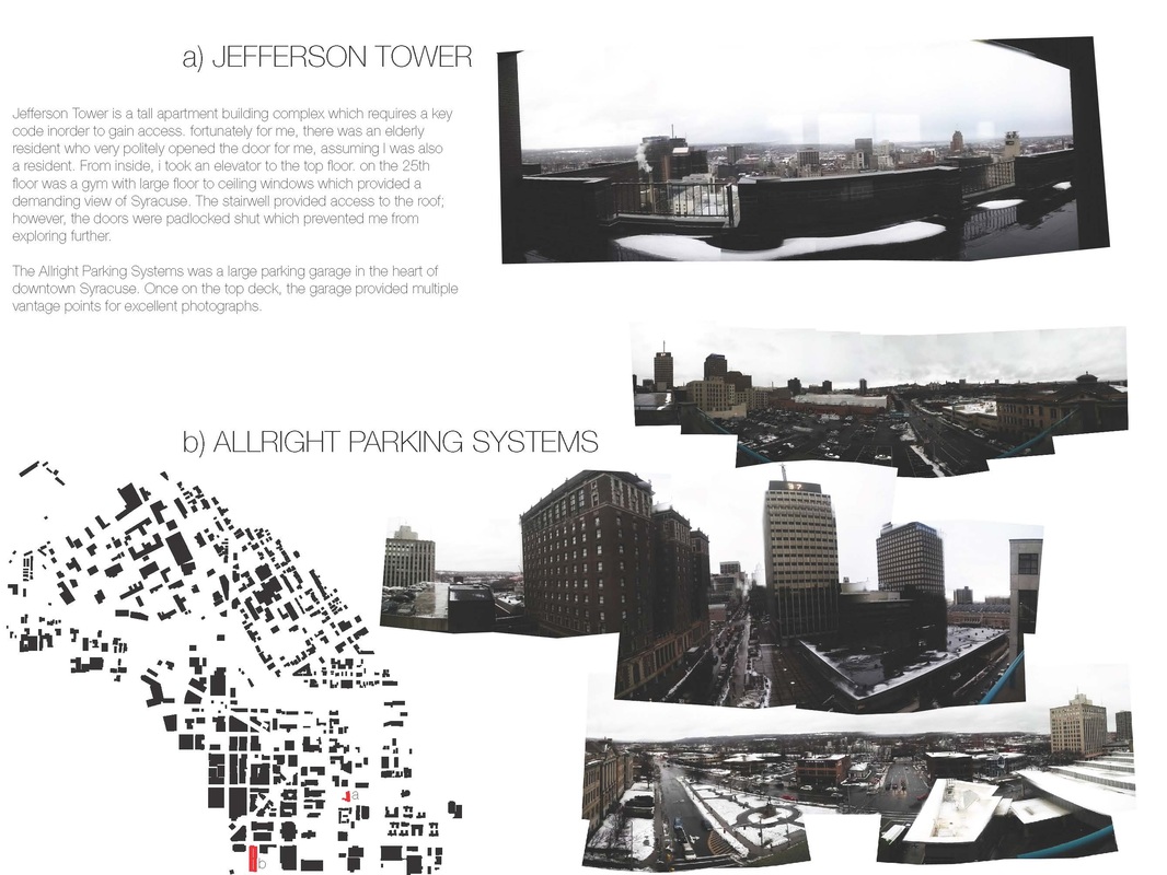
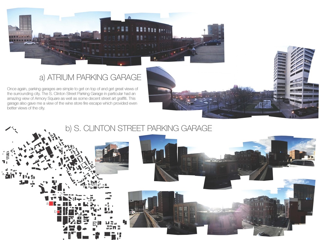
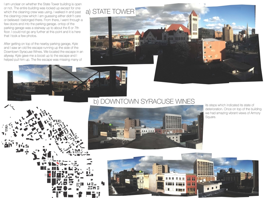
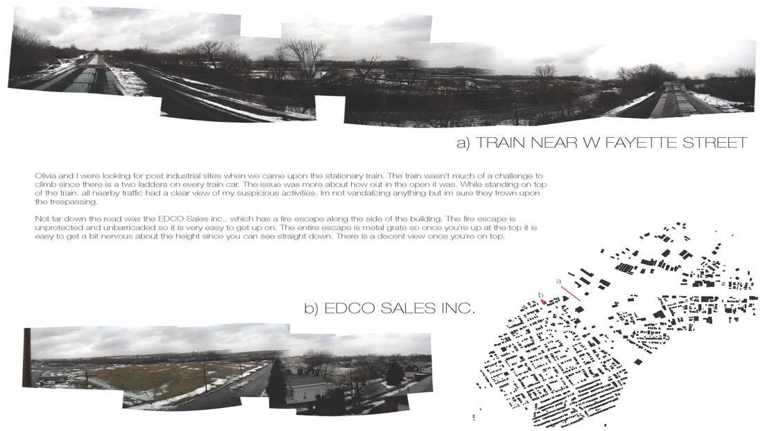
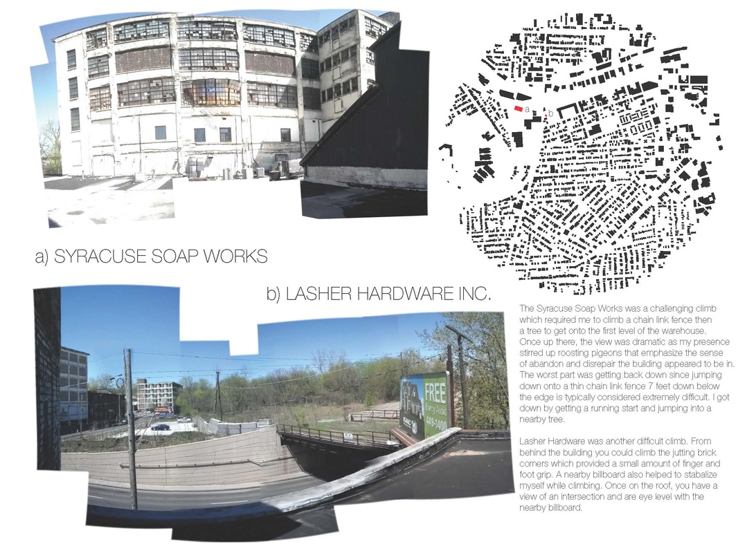
A place with a view
| final-board-saraagudelo-opt.pdf | |
| File Size: | 8845 kb |
| File Type: | |
| public_spaces_round_2.pdf | |
| File Size: | 79045 kb |
| File Type: | |
| corner_store_presentation.pdf | |
| File Size: | 42754 kb |
| File Type: | |
